
|
Un guide fortuit, qui peut aider les randonneurs à planifier leur randonnée sur le GR 34 Jusque-là, Sanssacados a tracé 3 itinéraires. Parce que nos itinéraires se poursuivent les uns après les autres, ils représentent un mois de randonnée; plus de 400kms. Cette année on espère tracer encore des itinéraires et elles continueront à partir de nos itinéraires actuels. Nous faisons cela pour nos clients. Nous parcourons les itinéraires et vérifions les campings. De plus, nous produisons des cartes permettant la navigation exactement jusqu’aux campings. Cependant, si cela crée une ressource aidant les randonneurs indépendants (qui n’ont pas besoin de nos services) à planifier leurs propres randonnées sur le GR 34, nous serions très heureux; partant du principe que toute publicité est une bonne publicité. 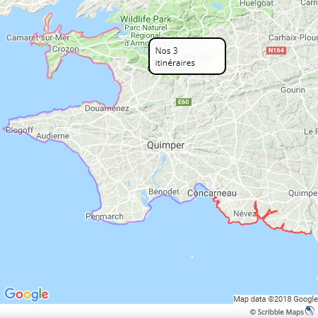 Plus de 400kms de marche sur le sentier côtier magnifique de Bretagne. Et les campings prévus pour tous les soirs. Pour tirer le meilleur parti de nos cartes, nous vous recommandons de télécharger l’application Viewranger. Si vous êtes un randonneur et que vous n'avez pas de smartphone, cette application est la meilleure raison pour en acheter un. Il transforme un smartphone en un appareil sophistiqué de système de positionnement global (GPS). Si vous achetez un smartphone, assurez-vous qu'il dispose de la fonctionnalité GPS et qu'il dispose d'une bonne batterie (le GPS est un gros consommateur d'énergie). Bien que l’application Viewranger soit gratuite, une mise à niveau intéressante consiste à acheter le droit de télécharger tout les cartes Série Bleue de IGN. Cela coûte 24 € par an, mais les cartes papier coûtent environ 11 € chacune. Si cela ne vous dérange pas de regarder une carte sur un petit écran, c'est une bonne affaire. Sans cette mise à jour, les cartes sont adéquates, mais rien ne correspond à la Série Bleue pour les détails. C'est merveilleux d'être n'importe où en France et de voir votre position indiquée sur une carte de la Série Bleue.  Plus besoin de nos fidèles cartes en papier? Nous avons tracé nos itinéraires en utilisant Viewranger, donc au bas de chaque carte de notre site Web se trouve un bouton vous invitant à ouvrir l'itinéraire dans l'application Viewranger (il peut s'agir d'un lien textuel sur les premiers routes).  Ce bouton se trouve au bas de toutes nos cartes Les randonneurs indépendants n'ont qu'à accéder à notre site Web pour voir la destination de leur journée. Là, ils peuvent voir la distance, l'ascension totale et, s'ils le souhaitent, suivre leur progression à l'aide de l'application Viewranger. Tous les liens des cartes se trouvent maintenant sur la même page. D'après notre expérience, les campings ont presque toujours de la place pour la petite tente du randonneur. La plus grande difficulté pour le randonneur indépendant sera d'acheter de la nourriture. C'est là que la planification sera nécessaire. Je vais essayer d'ajouter des informations utiles à la description de chaque jour sur notre site web. Mais, alors que les campings sont souvent situés dans des endroits magnifiques au bord de la mer, les magasins ne sont souvent pas proches. Le pain est généralement disponible le matin sur commande dans les campings. Mais il faudra de l'ingéniosité, ou un taxi, pour aller chercher d'autres produits. C'est pourquoi nous faisons les courses pour nos clients. Suivant nos itinéraires, un mois de marche pourraient débuter à Camaret sur Mer et se terminer au Pouldu (ou dans l’autre sens). Cela fait 25 jours de marche, permettre quelques jours de repos et voilà, un mois. N'hésitez pas à nous contacter si vous avez des questions et nous essaierons de vous aider dans votre aventure. 
3 Comments
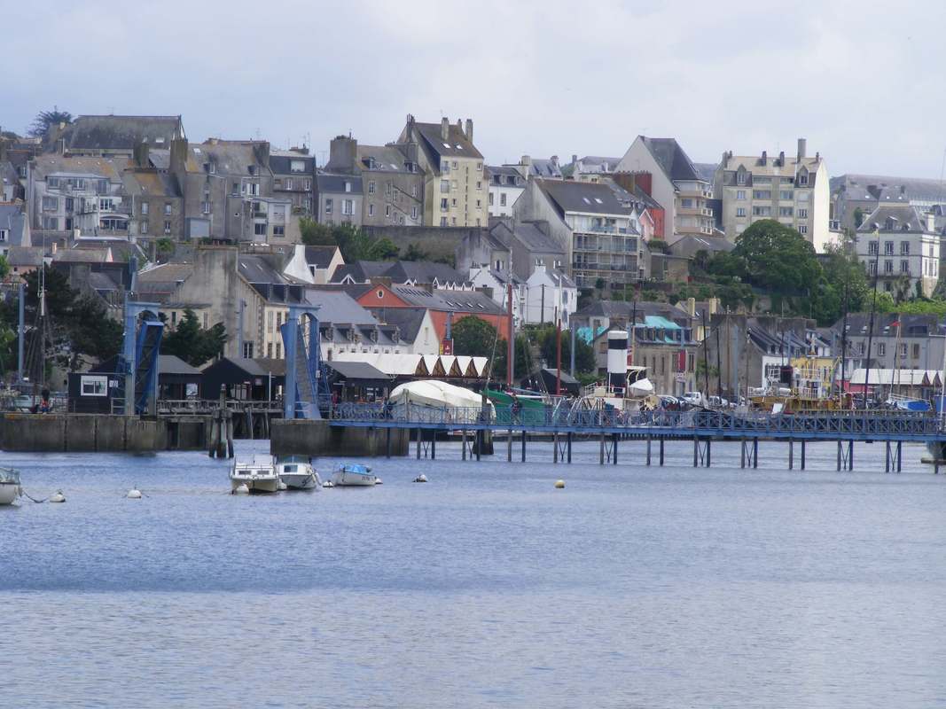
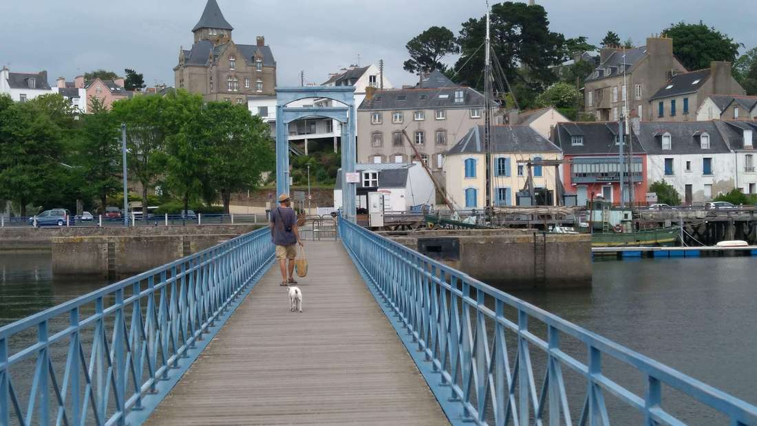
Douarnenez, commune and town, is particularly well situated. Tucked into the very end of the Bay of Douarnenez with Cap Sizun providing shelter from the prevailing south-westerlies and the Crozon peninsula protecting the northerly aspect. Sheltered and mild; who could ask for more? Certainly not sailors and fishermen. Douarnenez boasts 4 ports, if you include the modern marina, and it would be confusing and unfair to marina users not to. Residents of Douarnenez are spoilt for good walks and need only make up their minds which way to walk on the coast path. But whilst enjoying the staggering cliffs of Cap Sizun or the long beaches of the Bay of Douarnenez, they might well be thinking that they have better beaches at home - in town. 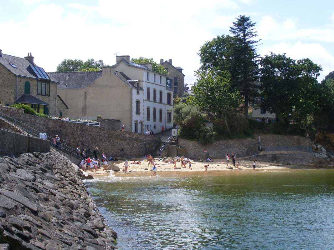 Plage St Jean, Douarnenez. One of four. 4 Ports and 4 beaches. Douarnenez has beautiful sandy beaches that enjoy the shelter and benign conditions making them somewhat more user friendly than the more atlantic beaches typically found on the caps and peninsulas on this westerly edge of Europe. Plage des Dames is perfectly sheltered and safe, although a café/bar teeters precariously on top of the wall that wraps around it. Plage St Jean (see photo) seems to appear from nowhere as you make your way around the coast as do many other tempting swimming spots. At Tréboul, Plage des Sables Blancs showcases the cosmopolitan, modern impression that Douarnenez exudes, contrasting with the largely agricultural nature of the region. Every conceivable water-based activity can be observed. Wet-suited enthusiasts march up and down, up to their waists in water in what’s called aqua-marche or marche-aquatique, sometimes performing Bretagne dancing. Kite-surfers and stand-up-paddlers go back and forth at their allotted speeds. Joggers, thoughtfully dressed signalling that this is not someone fleeing danger, pound the paths. 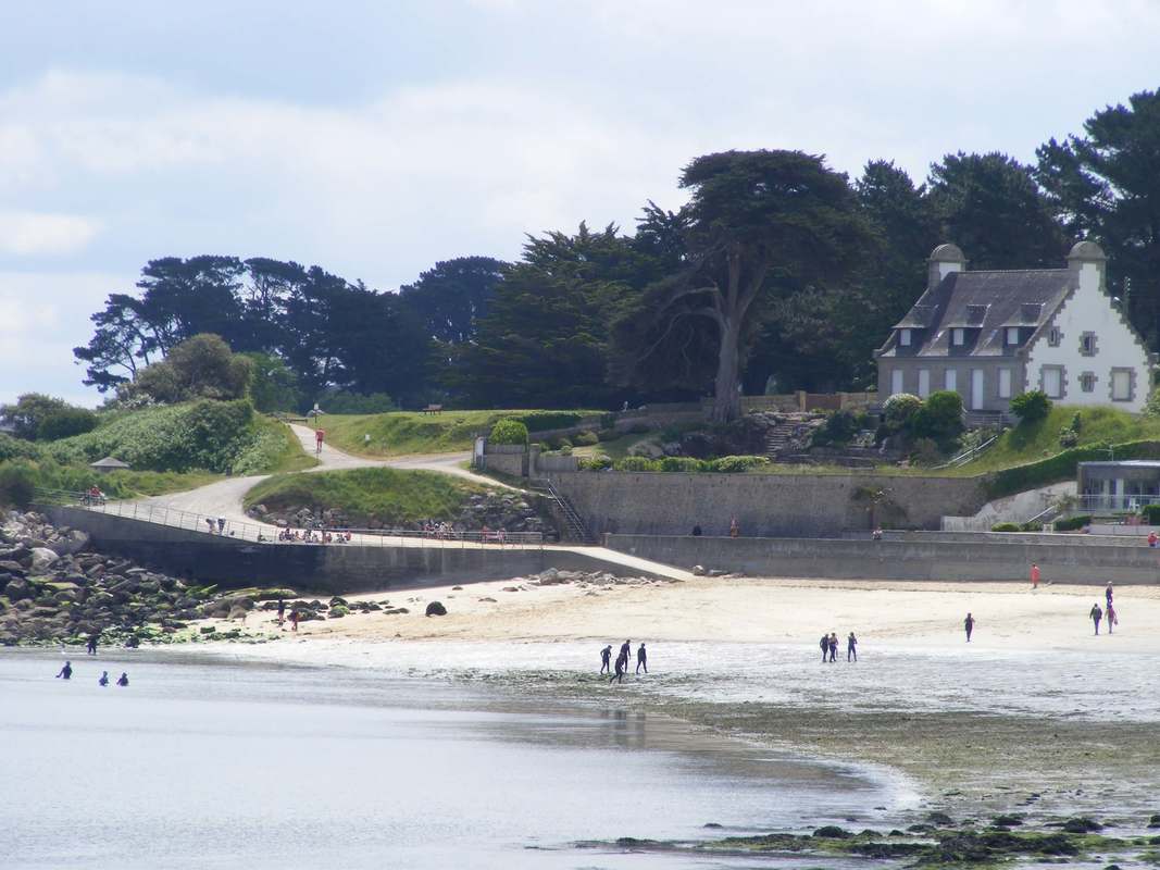 Plage des Sables Blancs, Douarnenez Of the 4 ports, Port Rhu is the most picturesque and the oldest. Formed in the estuary of the river Pouldavid it is what I understand to be a floating harbour (I am from very near Bristol where these things are important). I have seen it described as a “wet dock”, but that implies the opposite of a dry dock where as Port Rhu is a whole harbour where you can go where you will, whatever the state of the tide. This is achieved with a weir and a substantial lock. Best of all a passerelle crosses the weir with a neat little lifting bridge to let craft through at high tide. Fortunately, the passerelle or footbridge was built when beauty and elegance were regarded as hallmarks of good design - if it looks right, it probably is. And it is an attraction in itself. The coast path crosses the passerelle affording fine views of the floating harbour.
Port Rhu has been put to very good use following the decline of the fishing industry. Douarnenez has started to collect interesting boats and ships. This delightful mania is presented to the public as a maritime museum and folks are free to roam about the vessels as well as enjoying indoor exhibits. Traditional boat building is thriving along the port adding to the pleasant atmosphere, as do the bars and cafés. A great place to wile away some time. 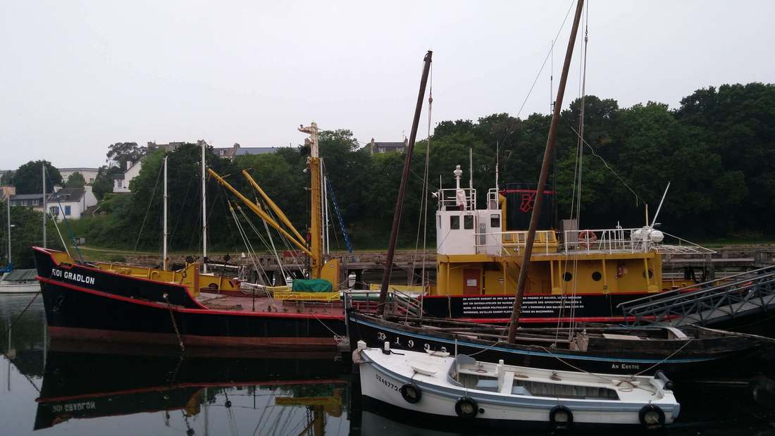 This tough little ship spent her working life servicing lighthouses and buoys. Now enjoying her retirement in Douarnenez. You can go aboard and look around. Perhaps in an attempt to lure in more interesting boats, a festival of classic boats takes place every 2 years, following on from the Tonnerre de Brest, a similar boat festival up the coast in Brest. “Tonnerre de Brest”, incidentally, was an expletive used by Captain Haddock in the original Tintin books. I can recommend the Tintin books if you wish to read, and perhaps learn, conversational French from the 1950s. The next festival of boats is in July 2019 from the 25th to the 29th. 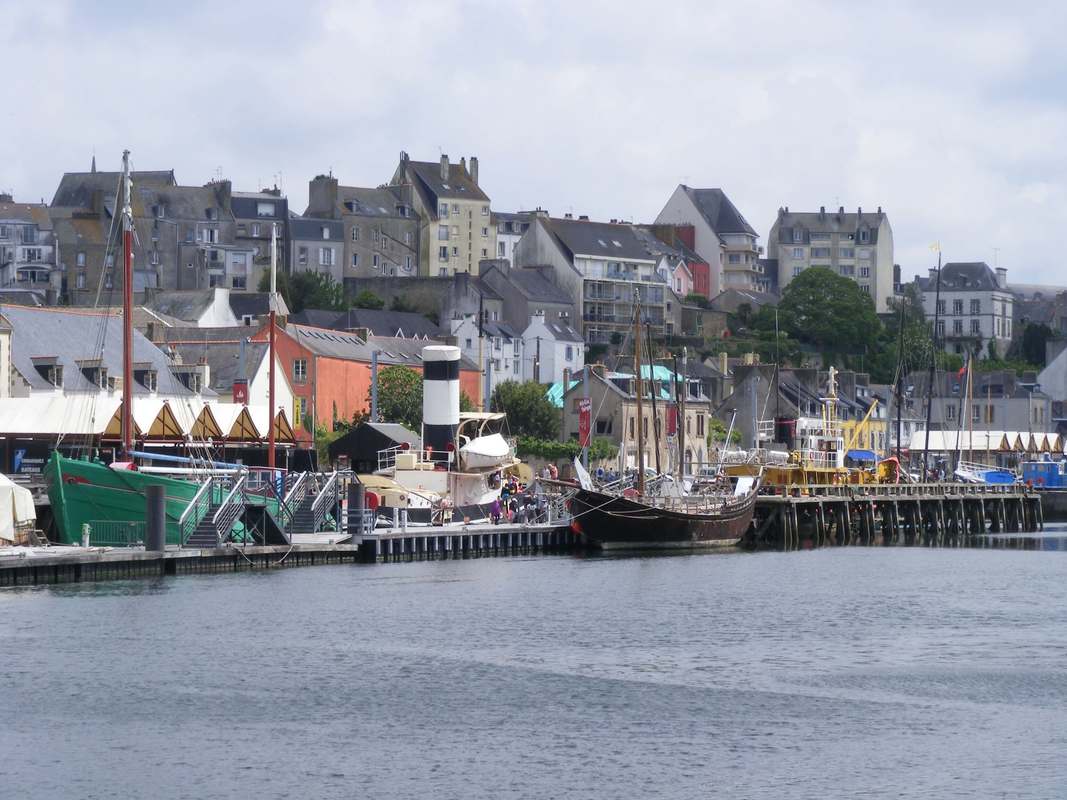 The maritime museum, Douarnenez Those wishing to see more of the town might follow the sardine trail which takes you around town looking at sites important to that industry. It’s worth doing even if you have only the merest interest in sardines as it shows off the town well. The sardine industry is all but gone from Douarnenez, but there are still canning facilities in the town. Tinned fish is not dismissed as a store-cupboard food in Brittany. There are shops (which I must admit took me by surprise), usually in the tourist towns, which sell nothing else, with some tins at very fancy prices. Tinned sardines were not Douarnenez’s first dally into the fish export market. Head for the Crozon on the coast path and you quickly gain the charming cliff-top village of Plomarch. Here the coast path takes you past some curious and well-preserved Roman remains in the form of vats. It’s not at all obvious what their purpose was. So the inquisitive are drawn to the signs which reveal that this was a production facility for garum, a fermented fish sauce. Plomarch is downwind of Douarnenez, probably the most important factor when choosing where to locate this facility. The recipe for the best garum hardly makes the mouth water: the intestines, blood and fins of tuna were mixed with salt then fermented in the vats for a couple of months. Lower grades were made with whatever fish could be gleaned. Don’t be put off, apparently this recipe has been recreated and it is rich in omega 3 fatty acids, vitamins and minerals - a 1st century health food, although it may have been responsible for spreading fish tapeworm around Europe; not so healthy. This sauce, used as a condiment, was widely popular and sent all over the place in amphorae. Although a different preservation method, not that dissimilar a concept to the export of tinned fish. 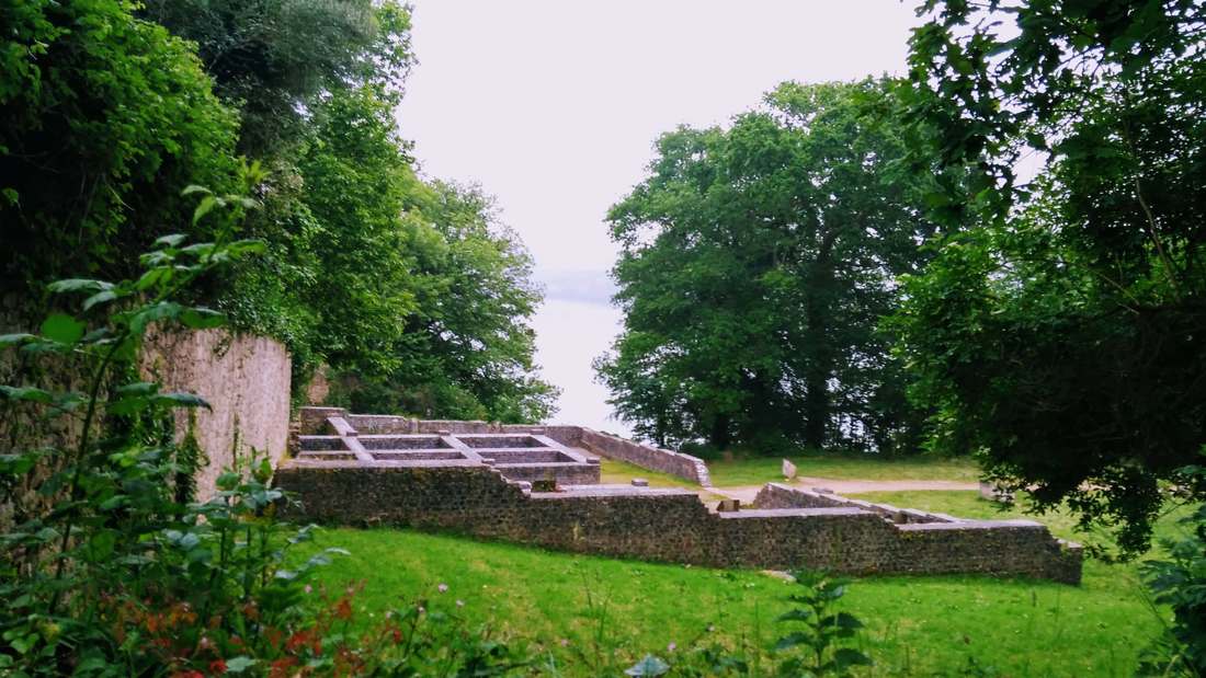 The Roman garum processing facility at Plomarch. Happily without authentic odours. Douarnenez also has a lost legendary city in its bay and a small island accessible at low tide packed with enough history for a considerably larger island. With Bronze age settlements, Arthurian ties, an abbey, a pirate garrison and Douarnenez's first canning factory all associated with île Tristan. It’s now part of the marine national park and is well worth a visit if tides allow. 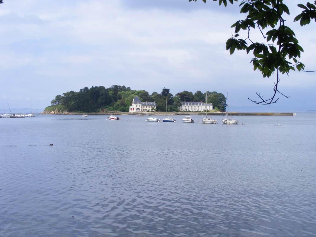 île Tristan, famous for everything from adulterous Arthurian heroes to tinned fish. The splendid town of Douarnenez falls between our Crozon and West Finistère itineraries and can be included in either.
|
AuthorWrite something about yourself. No need to be fancy, just an overview. ArchivesCategories |
 RSS Feed